GIS & Remote Sensing for Forestry in Uganda: Applications and Benefits
Geographic Information Systems (GIS) and remote sensing technologies have fundamentally changed the way forests are managed, monitored, and reported on — and Uganda is no exception. From plantation inventory and encroachment detection to carbon stock estimation and ESIA baseline mapping, GIS and remote sensing for forestry in Uganda now underpins the highest-quality environmental management work across the country. Euca Eco Consults Limited, based in Wakiso, Kampala, has built its GIS and remote sensing capability into every major service it offers — from plantation management to ESIA reporting — and this article explains why these technologies matter and what they can do for your forestry or environmental project.
What Are GIS and Remote Sensing?
Geographic Information Systems (GIS) are computer-based tools for capturing, storing, analysing, and displaying spatially referenced data — essentially, any information that has a location on the earth's surface. In forestry, GIS integrates data on land cover, topography, soils, ownership boundaries, road networks, and ecological features into a single analytical framework.
Remote sensing refers to the acquisition of information about the earth's surface without direct physical contact — typically using satellite imagery, aerial photography, or drone surveys. Uganda benefits from excellent coverage by free and commercial satellite data sources, including Sentinel-2 (10m resolution, ESA), Landsat (30m resolution, NASA/USGS), and Planet Labs (3m resolution, commercial). Combined with GIS analysis, these data sources deliver powerful insights at scales ranging from an individual plantation plot to the entire national forest estate.
Forest Inventory and Area Estimation
Accurate forest inventory — knowing what you have, where it is, and how much it is worth — is the foundation of every forestry business decision. Traditional ground-based inventory is expensive, time-consuming, and limited in coverage. GIS and remote sensing augment ground measurement with:
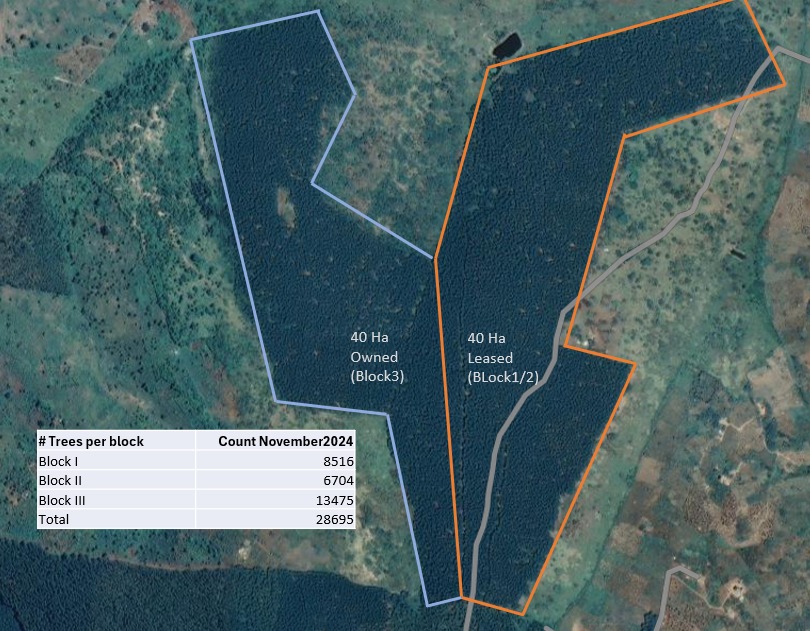
- Stand delineation: Automated mapping of plantation boundaries and internal management compartments using high-resolution satellite imagery
- Area calculation: Precise GIS-based area measurement of each compartment, providing auditable figures for landowners, NFA permits, and carbon project registration
- Canopy cover analysis: NDVI (Normalised Difference Vegetation Index) mapping to assess canopy closure and identify gaps requiring restocking
- Change detection: Multi-temporal imagery analysis to track plantation growth, detect encroachment, and monitor forest loss over time
Euca Eco Consults delivers GIS-based forest inventory reports that meet the documentation requirements of NFA permit applications, carbon credit project designs, and FSC certification processes.
Encroachment and Deforestation Monitoring
Protecting Your Investment with Satellite Monitoring
Encroachment — the unauthorised occupation or cultivation of plantation land — is a persistent challenge for forest owners in Uganda, particularly in densely populated districts like Wakiso, Mpigi, and Mubende. Annual ground patrols are expensive and often miss subtle, early-stage encroachment. Satellite-based change detection provides an efficient and objective alternative:
- Quarterly comparisons of high-resolution imagery reveal new clearings, structures, or cultivation within plantation boundaries
- GIS analysis generates spatial reports showing the precise location and estimated area of any encroachment event
- Time-stamped satellite evidence strengthens legal documentation for eviction proceedings or police reports
Expert Guidance Available
Map, Monitor and Manage Your Forest with GIS
Euca Eco Consults provides full GIS and remote sensing services for forestry and environmental projects across Uganda — inventory mapping, change detection, ESIA baselines, and carbon stock analysis.
Book Free ConsultationGIS Applications in Environmental Impact Assessment
NEMA increasingly expects GIS-supported spatial analysis in ESIA submissions. Applications include:
- Land cover mapping: Satellite-derived land use and land cover maps showing current vegetation types, wetlands, and built-up areas within the project zone of influence
- Sensitive area identification: GIS overlay of project footprint against gazetted forests, wetlands, and biodiversity hotspots to flag compliance risks early
- Viewshed analysis: Modelling the visual impact of infrastructure projects on scenic landscapes
- Hydrological mapping: Delineation of catchments, drainage patterns, and flood risk areas to support water-related impact assessment
For ESIA applications, see our detailed guide to the ESIA process in Uganda, which covers how GIS baseline data integrates with NEMA's submission requirements.
Carbon Stock Estimation and REDD+ Monitoring
For forestry projects seeking to generate carbon credits, GIS and remote sensing are essential tools for Measurement, Reporting and Verification (MRV). Applications include:
- Above-ground biomass estimation using allometric equations combined with GIS-mapped stand data
- Forest cover change analysis to quantify deforestation baseline rates required for REDD+ additionality calculations
- LiDAR-based canopy height modelling for high-precision biomass measurement in premium carbon projects
- Annual monitoring reports demonstrating continued carbon stock maintenance for carbon credit issuance
"GIS transforms forestry from an art based on experience and instinct into a science based on data. Our clients can see their forests in new ways — and make decisions backed by evidence rather than estimates."
— Euca Eco Consults GIS and Remote Sensing Unit, Wakiso
Drone Surveys: The Next Level of Precision
UAV (drone) surveys complement satellite imagery with ultra-high resolution data acquisition at specific sites or during critical management moments — such as post-planting survival assessments, pre-harvest inventory, or post-fire damage mapping. Drone-derived orthomosaics and digital surface models from Ugandan plantation sites can achieve centimetre-level accuracy, enabling individual tree crown delineation and precise volume estimation.
Euca Eco Consults integrates drone surveys into comprehensive forest monitoring programmes, providing clients with data products that support both operational management decisions and the evidence trail required for certification and carbon project reporting. For more on how GIS supports sustainable forest management in Uganda, see our article on sustainable forest management principles and practices.
Accessing GIS Services for Your Forestry Project
Whether you manage a 50-acre eucalyptus plantation in Wakiso or a 2,000-hectare pine estate in western Uganda, GIS and remote sensing technology can improve your decision-making, reduce your monitoring costs, and strengthen your reporting. Euca Eco Consults Limited provides a full range of GIS and remote sensing services tailored to Uganda's forestry and environmental sectors. Contact us in Kampala today to discuss how spatial technology can add value to your specific project — from a single boundary survey to a full carbon MRV programme.
Over a decade of forestry and environmental consultancy experience across Uganda. Specialists in eucalyptus, pine, GIS, ESIA, and ESG from our base in Wakiso, Kampala.